📢 Loạt tính năng mới: Kết nối tài khoản Diễn Đàn với toàn bộ Thư Viện (Truyện/Thơ/Nhạc/Phim/Ẩm Thực)
Xin chào cả nhà!


Ban quản trị vừa hoàn tất một loạt tính năng mới, kết nối tài khoản Diễn Đàn với toàn bộ các khu vực Truyện, Thơ, Nhạc, Phim và Ẩm Thực. Xin tổng kết lại để mọi người tiện theo dõi và sử dụng:

1. Đăng nhập dùng chung toàn site
Chỉ cần 1 tài khoản Diễn Đàn, đăng nhập một lần là dùng được ở mọi khu vực. Nút "Đăng nhập / Đăng ký" đã thay cho "Giới thiệu / Trợ giúp" cũ ở đầu mỗi trang.

2. Thảo luận ngay dưới tác phẩm
Mỗi truyện, bài thơ, bài hát, phim, món ăn giờ có khung bình luận riêng ngay trên trang đọc/nghe/xem - không cần qua diễn đàn mới góp ý được. Bình luận đầu tiên sẽ tự tạo 1 chủ đề trong mục "💬 Thảo Luận Tác Phẩm Thư Viện" để mọi người cùng trao đổi.

3. Theo dõi tác phẩm
Bấm "🔔 Theo dõi tác phẩm" để nhận thông báo qua email ngay khi truyện có chương mới.

4. Yêu thích & Lịch sử đọc
Đánh dấu "⭐ Yêu thích" các tác phẩm ưng ý, và hệ thống tự ghi lại "🕘 Lịch sử đọc" mỗi khi bạn ghé đọc/nghe/xem - đồng bộ theo tài khoản, xem lại bất cứ lúc nào trong menu thành viên.

5. Huy hiệu hoạt động
Một vài huy hiệu nhỏ (bình luận viên, người theo dõi, người sưu tầm, thành viên kỳ cựu...) sẽ tự xuất hiện trên hồ sơ khi bạn hoạt động tích cực - hoàn toàn không phải hệ thống điểm/tiền thưởng, chỉ mang tính ghi nhận cho vui.

6. Ghi công người đóng góp
Tên người đăng nội dung (đánh máy, sưu tầm...) giờ sẽ tự động liên kết về hồ sơ Diễn Đàn nếu trùng với một tài khoản đang có trên diễn đàn.

7. Báo lỗi nội dung
Phát hiện lỗi chính tả, thiếu nội dung, ảnh hỏng... trong lúc đọc? Bấm "🚩 Báo lỗi nội dung" ngay trên trang, không cần rời khỏi tác phẩm đang xem.

8. Cải thiện giao diện trên điện thoại
Đầu trang và khu vực diễn đàn đã được chỉnh lại cho gọn gàng hơn trên màn hình nhỏ.

Rất mong nhận được góp ý thêm từ cả nhà để hoàn thiện dần. Cảm ơn mọi người đã luôn đồng hành cùng Việt Nam Thư Quán!

Diễn Đàn » English Club

Natural Disasters * North America

208 trả lời, 31.552 lượt xem — Trang 2 / 7
How are tornadoes created?

Tornadoes develop near the boundary between the upcurrents and downdraughts in a storm cloud. A 'funnel cloud' develops first from the cloud base and this may then extend down to ground level. 'Waterspouts' are simply tornadoes that form over water rather than land. They tend to lose their energy as soon as they cross from water to land. Waterspouts are usually confined to shallow waters during warmer seasons.The destruction caused by tornadoes is due mainly to the violence of the winds. There is very low pressure at the centre of the vortex. If a tornado goes over a building it can explode outwards because of the sudden drop in pressure as the vortex passes over the building. Although they are usually less than 250 m across, they can travel a long way, sometimes more than 200 km (125 miles) across the land surface. They pick up material from the ground as they go, including cows, cats, dogs and other animals - including humans! They can be the source of some very strange weather indeed! Find out more about tornado chasers, and how you can protect yourself from severe weather.


http://www.bbc.co.uk/weather/weatherwise/factfiles/extremes/tornadoes.shtml
Đăng nhập để trả lời
0
Hail

Hail is produced inside storm clouds and is made of solid ice. Hailstones can grow to dangerous sizes before they fall and have to be at least 5 mm (0.2 in) across to be considered as hail. If the particles of opaque ice are smaller than this they are known as 'soft hail' (graupel or snow pellets).

The hazards of hail?
Hail occurs when ice pellets falling from the top of the cloud collect a film of moisture as they descend. The moisture freezes when the pellets are carried back to the top by upcurrents. As this process is repeated the hailstones grow in size and each trip through the cloud adds a new layer of ice. Once hailstones become heavy enough they will fall to the ground and can be a really dangerous weather hazard. Most are smaller than 2.5 cm (1 in) in diameter, but some can be as big as tennis balls or even grapefruit size. The largest can weigh a little under 1 kilo and fall at more than 50 metres per second. Hail storms can devastate entire fields of crops in a few minutes, flattening and bruising the growing plants. The biggest hailstones in the world tend to fall in north-east India. In Britain there were last hailstorms with tennis ball-size hail stones in Horsham in 1958 (5 September) and Wokingham in 1959.

http://www.bbc.co.uk/weather/weatherwise/factfiles/extremes/hail.shtml
Đăng nhập để trả lời
0
Hurricanes

These tropical storms are called hurricanes over the North Atlantic Ocean, cyclones over the Indian Ocean and typhoons over the north-west Pacific. Sea surface temperatures must be above 26.5 degrees C for hurricanes to form. A hurricane is one of the most powerful of all weather systems powered by the heat energy released by the condensation of water vapour. High speed winds (occasionally reaching 350 km/h (200 mph) ) spiral around a calm low pressure "eye", often clearly seen in satellite photos.

As well as causing damage with its violent winds, they also cause flooding on low lying coastlines with an associated storm surge. This is caused by the intense low pressure at the eye of a hurricane combining with the effect of strong winds to raise the ocean surface by 3-4 metres. The sea rises 1 cm for every millibar so if the pressure is 930 millibars, the sea surge will be about 80 cm. The hurricane winds will push the surge along in front of its path. On the lee side of a hurricane, the sea level may actually fall as the winds blow back round the hurricane pushing the water away. Coastal regions can also get battered by huge waves on top of the surge effect. In addition there can be flooding overland as a result of torrential rainfall that falls out of the storm's cumulonimbus clouds

http://www.bbc.co.uk/weather/weatherwise/factfiles/extremes/hurricanes.shtml
Đăng nhập để trả lời
0
Floods
Floods can be deadly, particularly when they arrive without warning. Some are the result of sudden and torrential rain in the local area, while others are caused by melting snow, or by large amounts of rainfall over a wide area.

The damage floods cause?
Occasionally a river bursts its banks, or the sea might surge over a coastline during a storm. Prolonged rain can produce a river flood as water from upstream tributaries gradually builds up. Areas near to the junctions of major rivers are especially vulnerable to this type of flooding.One of the worst aspects of flood damage is the contamination of drinking water supplies by sewage and other waste. It can take months for the destruction to be cleaned up. Now, in Britain there is a flood warning system managed by the Environment Agency and the BBC Weather Centre broadcasts flood alerts

http://www.bbc.co.uk/weather/weatherwise/factfiles/extremes/floods.shtml
Đăng nhập để trả lời
0
Sunday, 13 March, 2005, 17:32 GMT


New wells are to be drilled in affected rural areas of Thailand


Drought hits Thailand's economy

A drought in Thailand could affect economic growth this year, Prime Minister Thaksin Shinawatra has said.
"It will have an impact on GDP growth. The drought is extremely severe this year. If the May rains arrive late we could see greater damage," he said.

The drought is hitting most of the country - with water in many dams declining significantly.

http://news.bbc.co.uk/2/hi/business/4345551.stm
Đăng nhập để trả lời
0
MONDAY
14th March 2005

Severe Thunderstorms

Storms are the most impressive of the everyday weather events and can cause lots of damage. They bring heavy rain, lightning, hail and sometimes tornadoes and waterspouts. During a thunderstorm the sky is dominated by towering cumulonimbus clouds. These can reach heights of up to 19 km (12 miles). High level winds sculpt the top of the cloud to an anvil. Inside each cloud, tremendous energy is generated and unleashed in the form of swirling upcurrents and spectacular bursts of high-voltage electricity.

How is storm energy created?

Large amounts of heat energy are released as water vapour first condenses and then freezes inside the cloud. The heat energy creates powerful rising air currents that swirl upwards to the tropopause. Cool descending air currents produce strong downdraughts below the storm. After the storm has spent its energy, the rising currents die away and downdraughts break up the cloud. At any particular moment in time there are approximately 2,000 thunderstorms occurring in the Earth's atmosphere. A typical storm lasts about 1-2 hours. Individual stormclouds can measure 2-10 km across. Find out more about stormchasing, and how to protect yourself from severe weather.

http://www.bbc.co.uk/weather/weatherwise/factfiles/extremes/storms.shtml
Đăng nhập để trả lời
0


Blizzards and Sandstorms

Snow and sand are drifted by the wind in polar and desert regions, but as these are not highly populated, usually little disruption is caused. When there is a blizzard in a populated area however, it can paralyse all forms of transport and reduce visibility completely. Blizzards are snow storms in which visibility is very seriously reduced. Snow can also creep along the ground or be bounced around by winds in a process called saltation.

Sand and dust are a hazard
Sandstorms can rapidly change the appearance of an area with the shifting and re-forming of dunes by the wind. Dust storms in arid regions can be formed when small, light dust particles are blown in to the air, often lifted by the strong winds at the leading edge of a cold front. In some drought prone areas, a 'dustbowl' effect can be caused by prolonged drought over a long period because of persistent failure of the rains, and often exacerbated by overgrazing.

http://www.bbc.co.uk/weather/weatherwise/factfiles/extremes/blizzards.shtml
Đăng nhập để trả lời
0


Sea and Air Hazards

Ships and aircraft are always keeping watch on the weather as it creates special problems for them. At sea, waves and swell produced by storms are the major hazards. A storm can transform the sea's surface into an unpredictable force - waves of up to 18 m (60 ft) are fairly common. The largest documented wave measured 34 m (112 ft) in height.


Pilots need special training
In the air, the main dangers are hailstones and strong upcurrents and downdraughts produced by storms. Hailstones more than 1 cm in diameter can damage an aircraft. Pilots are trained to avoid the dangers of hail by flying around rather than beneath storm clouds. Sudden changes in wind velocity are one of the most dangerous hazards facing aircraft that are coming in to land. A thunderstorm can produce unexpected vertical downbursts of 90 km or more. Flying through a downburst may cause the aircraft to crash.

Thick fog which can conceal coastlines and runways is another common hazard. Lighthouses built on the coast or on offshore rocks use both light and sound to warn ships of fog. The sound of a lighthouse foghorn can be heard for about 30 km (20 miles) over water. Some airports have fog dispersal systems which use hot air to evaporate the fog on the main runway for clear take-offs and landings.

http://www.bbc.co.uk/weather/weatherwise/factfiles/extremes/hazards.shtml

Đăng nhập để trả lời
0

The floods followed Afghanistan's worst winter in years


Sunday, 20 March, 2005, 11:00 GMT

Afghan floods kill more than 200
More than 200 people are now known to have been killed by severe flooding in Afghanistan, after torrential rain and melting snow caused rivers to overflow.
Officials in the worst-hit area, the central province of Uruzgan, say thousands of homes have been destroyed and many more people are still missing.

The floods have inundated farmland and swept away cattle, sheep and goats.

US military helicopters have rescued about 250 people and the UN World Food Programme (WFP) has sent in supplies.

Last month, the WFP warned that Afghanistan was facing catastrophe as snow began melting from the country's worst winter for decades.

The harsh conditions also took their toll on the population, with more than 300 people thought to have died of cold-related illnesses.

As well as Uruzgan, the western provinces of Farah and Herat, the central province of Ghor and the northern province of Faryab have also been badly affected.

http://news.bbc.co.uk/2/hi/south_asia/4365623.stm
Đăng nhập để trả lời
0

King Bhumibol is keenly involved in environmental projects


Tuesday, 27 May, 2003, 11:21 GMT 12:21 UK

Thai king's patent to make rain

Thailand's King Bhumibol Adulyadej is to receive a patent for his development of an artificial rain-making technique.
The patent will be granted for the King's "super-sandwich" technique, which involves using aircraft to "seed" warm and cold clouds at different altitudes to make rain.

Seeding involves using chemicals to trigger rainfall in clouds, and the King's technique is said to be particularly successful in that it can more precisely target areas where the rain is to fall.

The Thai king is involved in a number of environmental and agricultural projects, and this will be the fourth patent he has been awarded.

The Bangkok Post reported that Indonesia and some Middle Eastern nations have sought details of the King's technique.

The patent will be presented on 2 June, at his seaside residence in Hua Hin.

King Bhumibol has been on the throne since 1946. He is regarded highly by his people, and some even see him as a god-like figure.

http://news.bbc.co.uk/1/hi/world/asia-pacific/2940430.stm
Đăng nhập để trả lời
0
Thailand's agricultural industry has been hard hit by the drought


Thursday, 17 March, 2005, 15:37 GMT

Thai king aims high over drought

Thailand's King Bhumibol Adulyadej is to oversee personally an artificial rain-making project in a bid to end a severe drought in the country.
He is expanding a cloud-seeding technique he patented in 2002, which involves aircraft releasing a chemical into clouds to induce rainfall.

He suggested the idea as most of Thailand's 76 provinces face their worst drought for several years.

An additional 17 aircraft have been drafted in for the scheme.

It has also been expanded from 10 to 22 bases across the country.

"The king has set up a centre for rain-making at Hua Hin [his seaside residence] and will personally command the centre to help alleviate drought," Deputy Agriculture Minister Newin Chidchob told the AFP news agency.

Disaster zones

Cloud-seeding involves firing particles, usually silver iodide, into clouds to encourage water vapour to gather round them and eventually fall as rain.

CLOUD SEEDING


1. Aircraft or artillery spray chemicals (often silver iodide or dry ice) into clouds to encourage tiny vapour droplets to coalesce
2. Droplets of supercooled water (liquid below freezing) coalesce into snow and melt as they fall
3. Heat released as the droplets freeze boosts updrafts, which pull more moist air into the cloud


King Bhumibol Adulyadej's technique involves using two aircraft to seed warm and cold clouds at different altitudes.

This technique is said to be particularly successful because it can more precisely target areas where the rain is to fall.

The monarch is said to have suggested his rain-making technique after expressing his concern about the drought during a meeting with Prime Minister Thaksin Shinawatra.

The drought has affected more than 8.3 million people, and 10 areas in the northern province of Chiang Mai have been declared disaster zones.

It also hit Thailand's fourth quarter economic results by significantly affecting output in the agricultural sector.

http://news.bbc.co.uk/1/hi/world/asia-pacific/4358535.stm
Đăng nhập để trả lời
0

Thailand King


Friday 18/3/2005, 15:46 GMT+7

http://www.vnexpress.net/Vietnam/The-gioi/2005/03/3B9DC677/
Đăng nhập để trả lời
0
Crews are already at work on 40-meter-high dam which will flood 450-square-kilometers of land and 17 villages


Laos Faces Challenge of Using Water Resources to Ease Poverty While Protecting Environment
By Scott Bobb
Nakai, Central Laos
21 March 2005

Unlike many parts of the world with water shortages, the small Southeast Asian nation of Laos has hundreds of rivers draining the highlands along its border with Vietnam. The challenge facing Laos is how to use its water to alleviate poverty without damaging the environment.

Correspondent Scott Bobb visited central Laos and reports on a dam project the government says will boost economic growth, but that some environmentalists fear will endanger a forest conservation zone in the region.

It is late afternoon in Thalang, a village of several hundred people in central Laos, 100 kilometers from the nearest paved road.

Chickens and pigs forage for food in the hardscrabble earth around wooden houses on stilts.

Thalang's inhabitants eke out a living by fishing and tending small gardens along the Nam Theun, a river that flows from the mountains near Vietnam to the Mekong River.

Thalang is doomed.

The government wants to build a dam on the Nam Theun that will flood Thalang and 16 other villages in the area. Six thousand people will lose their homes.


Mrs. Thorn, mother of five, has visited the model village and says she wants to move


Mrs. Thorn, a mother of five, has lived in Thalang for most of her life, but she is ready to leave.

"I want to move," she says. "I will have a new house with electricity and land to cultivate. It's hard here. My family is very poor. We don't have enough rice."

The Nam Theun Power Company, which is building the dam, has built a model village of new homes and a neighborhood school 30 kilometers away on higher ground. Mrs. Thorn and her neighbors have seen the houses, which have electricity and running water. And they like them.


Impasith Thathongsakd
The company's resettlement manager, Impasit Thathongsakd, says the most important thing is consultations with the people and detailed planning.


"We tell them the project components and the benefits of the project, and the impact, of course, all good and bad," he said. "The most important thing is for them to understand in depth how the project affects them."

Excavators are already at work on the dam, which is to be completed in four years at a cost of $1.2 billion.

It will flood 450-square-kilometers of land on the Nakai Plateau. Water from its reservoir will generate 1,000 megawatts of electricity - enough to light more than 750,000 homes.

Laos will sell most of the power to neighboring Thailand to fuel its booming economy. The power will earn the Lao government $80 million, or one-fifth of its current budget.

The money could fund development projects, create jobs and improve social services in one of the region's poorest countries.

However, some environmental groups worry that the dam will open up a nearby forest preserve to poachers and illegal loggers, threatening tigers, elephants and other endangered species.


Gary Oughton says dam projects can benefit the rural poor if funds are provided during the construction phase to support them as their sources of livelihood change
Gary Oughton, an agriculture expert with the environmental consulting company EcoLao, says dams can severely damage forests.

"You will inundate some of their [villagers] lands, and you will force them uphill into the forests, put more pressure on wildlife and natural resources, unless proactive measures are taken," he said.

He adds that dams also affect fish populations and soil quality downstream, as well as the lives of people whose lands are flooded.

The more outspoken critics of the dam say the reservoir will be too shallow and could dry up during droughts. They say that during rainy seasons, on the other hand, heavy water flow could flood fields and pastures downstream. They add that dam projects rarely benefit the rural poor and mostly provide funds to governments, which are vulnerable to corruption.

..................

http://www.voanews.com/english/2005-03-21-voa24.cfm
Đăng nhập để trả lời
0
Water Becoming More Precious Than Oil in Arab World

Fishermen on the Nile, near Luxor, Egypt


By Greg LaMotte, Cairo
21 March 2005

While one of the most pressing political and social issues facing the Arab world rarely makes headlines, it is an issue that some political analysts believe could lead to the next great confrontation in the region. Rapidly expanding Arab populations are making water far more precious than oil.

From a historic perspective, the modern Arab world was built on the back of oil.

Since the first oil well gushed in Bahrain in 1932, countries have argued over boundaries and borders in hopes of gaining a piece of land that might produce instant wealth.

But during a decades-long process, borders have been set, oil fields have been mapped, and accurate estimates have been made of oil reserves in the region.
....................

http://www.voanews.com/english/2005-03-21-voa14.cfm
Đăng nhập để trả lời
0

Some villagers are still hunting for missing relatives


Friday, 3 June, 2005, 09:17 GMT 10:17 UK

Floods kill dozens in south China

By Rupert Wingfield-Hayes
BBC News, Beijing

The death toll from flooding in China has now passed 70, with hundreds of thousands more driven from their homes.

Torrential rain has been pounding large areas of southern China for the last five days, swelling rivers and washing away villages.

With many remote areas still cut off, local officials say the death toll may rise much further.

China's annual rainy season is less than a week old, but already it is wreaking havoc.

Across a huge swathe of southern China up to 20cm (8in) of rain have been falling every day this week.

The results are predictable. Rivers have burst their banks, mud slides have engulfed whole villages. In worst-hit Hunan province 50 are dead, another 50 are missing.

Around 200,000 more have been forced into temporary shelters. Thousands of hectares of farmland lie under water and mud.

Such disasters hit China every summer. Flooding is made worse by widespread destruction of forests and reclamation of flood plains for farmland. But the really worrying thing this year is that the annual destruction has begun so early

Đăng nhập để trả lời
0


http://www.bbc.co.uk/vietnamese/regionalnews/story/2005/06/050603_chinaflooding.shtml
Đăng nhập để trả lời
0
Sunday, 5 June, 2005, 09:43 GMT 10:43 UK

Deaths from China floods top 200


Hunan has been hardest hit with 60 confirmed dead


The number of people killed in torrential rains at the start of China's annual flooding season has risen to more than 200.
The worst-hit areas have been the south-western provinces of Hunan, Sichuan and Guizhou.

About 17m people have been affected, either losing property or being forced to flee, the Xinhua news agency said.

Local authorities have been ordered to mobilise manpower to prevent rivers and reservoirs bursting their banks.

Swept away

A week of torrential downpours in many parts of the country has killed 204 people, with 79 more missing and tens of thousands of farm animals left dead, Xinhua said.

Almost 140,000 homes and 614,000 hectares (1.5m acres) of farmland have been destroyed.


Flooding in Kaixian in the south-west Chongqing municipality


Vice-Premier Hui Liangyu has demanded the swift relocation of those made homeless and measures to ensure the protection of reservoirs.

Operations are under way to provide relief materials and the health ministry has issued a circular on preventing outbreaks of disease.

Hunan in south-central China is the hardest-hit province, with 60 people confirmed dead, 43 of those in Xinshao county.

Bridges there were washed away and buildings crumbled as flood waters swept through.

Southern Guangdong province has put the cost of its flooding so far at 55m yuan ($6.7m).

Meteorologists have warned that this year could see worse flooding than last, with two massive belts of rain predicted over the summer months.

The BBC's Francis Markus in Shanghai says there is no real consensus on the extent to which climate change is to blame.

However, he says that as population growth puts ever more intense pressure on China's farm land, it is clear that such factors as erosion are playing their part in worsening the impact of natural disasters.

http://news.bbc.co.uk/2/hi/asia-pacific/4610895.stm

>>>>>>>>>>>>>>>>>>>>>>

Vietnamese:
http://www.bbc.co.uk/vietnamese/regionalnews/story/2005/06/050605_china_flood.shtml
Đăng nhập để trả lời
0


Thursday, 5 February, 2004, 00:57 GMT

Lula visits Brazil flood victims


Brazil's president has visited northern states hit by severe flooding in a month of heavy rains.
At least 91 people have died and up to 117,000 have been forced out of their homes in the poor north-eastern states of Pernambuco, Bahia and Piaui.

Luis Inacio Lula da Silva said he was shocked by the scale of the damage in a region more used to water shortages.

He promised emergency food and shelter for the homeless and pledged funds to rebuild some 4,000 destroyed homes.

With more rain forecast, the worst-affected states say they have not been given enough emergency funds to deal with the immediate aftermath.

Emergency workers have been scrambling to rescue people trapped in towns that have become islands, provide temporary accommodation in schools and shelters and tend to dozens of injured.

Most of the victims either drowned or were crushed to death when mudslides caused their homes to collapse.

About 4,200 houses have now been destroyed and a further 112,800 damaged since late December.

'Slow and bureaucratic'

President Luis Inacio Lula da Silva - or Lula, as he is better known - said the floods had disproportionately affected the poorest Brazilians whose homes line river banks in low-lying areas.

On a visit to the region, he said his government would distribute food, drinking water, drugs and tents to victims of the flooding.

"We will do all that we can to minimise your immediate suffering and then, in a second phase, improve conditions so that you will not be victimised by floods again," he told people in Piaui.

On Wednesday, a Brazilian Air Force C-130 Hercules aircraft was distributing 18 tonnes of food around the region.


Some states complain of insufficient funding to help survivors


But governors of the states affected have complained that the 32 million reais ($11m) of funding they have received from two ministries was not enough.

"It's a small amount, and it's coming slowly," said Jarbas Vasconcelos, governor of Pernambuco, according to Globo news.

"We don't question that there's good will, and the intention to help, but the process is slow and bureaucratic," he said.

The wealthier, southerly state of Sao Paulo has also been badly hit, with 16 bridges washed away and motorists swept off roads that turned into rivers, according to Reuters news agency.

It said 29 people had died there.

http://news.bbc.co.uk/1/hi/world/americas/3457579.stm

>>>>>>>>>>>>>>>>>

Vietnamese:
Sunday, 05/06/2005, 17:41
http://www.tienphongonline.com.vn/Tianyon/Index.aspx?ArticleID=11537&ChannelID=5


Đăng nhập để trả lời
0
All 309 Survive Plane Crash in Toronto

By ROB GILLIES and BETH DUFF-BROWN,
Associated Press Writers
1 hour, 32 minutes ago

TORONTO - A jetliner carrying 309 people skidded off a runway while landing in a thunderstorm Tuesday, sliding into a ravine and breaking into pieces, but remarkably everyone aboard survived by jumping to safety in the moments before the plane burst into flames.

ADVERTISEMENT


Fourteen people suffered minor injuries in the 4:03 p.m. crash landing of Air France Flight 358 from Paris — the first time an Airbus A340 had crashed in its 13 years of commercial service.

The plane, carrying 297 passengers and 12 crew, overshot the runway by 200 yards at Toronto's Pearson International Airport, said Steve Shaw, a vice president of the Greater Toronto Airport Authority.

The aircraft skidded down a slope into a wooded area next to one of Canada's busiest highways, and some survivors said that passengers scrambled up to the road to catch rides with passing cars.

"The plane touched ground and we felt it was going off road and hitting a ravine and that's when we thought that was really the end of it," said Olivier Dubois, a passenger who was sitting in the rear of the A340 Airbus.

"It was really, really scary. Everyone was panicking," Dubois told CTV. "People were screaming and ... jumping as fast as possible and running everywhere, because our biggest fear is that it would blow up."

Roel Bramar, who was also in the back of the plane, said he used an escape chute to get out of the plane.

"We had a hell of a roller coaster coming down the ravine," Bramer told CNN.

They said the power went off shortly before landing, perhaps after the plane was hit by lighting. But Dubois said he did not expect a crash landing and that there was no warning from the captain.

"It was very very fast," Dubois said. "As soon as the plane stopped, they immediately opened the side of the plane where we couldn't see anything and they told us to jump."

He said some passengers scrambled onto nearby Highway 401, where cars stopped, picked them up and took them to the airport. Two busloads of passengers were taken to an airport medical center.

Corey Marks told CNN he was at the side of the road when he watched the plane touch down and crash.

"It was around 4 o'clock, it was getting really dark, and all of a sudden lightning was happening, a lot of rain was coming down," Marks said. "This plane ... came in on the runway, hits the runway nice. Everything looked good, sounds good and all of a sudden we heard the engines backing up. ... He went straight into the valley and cracked in half."

A row of emergency vehicles lined up behind the wreck, and a fire truck sprayed the flames with water. A government transportation highway camera recorded the burning plane, and the footage was broadcast live on television in Canada and the United States.

A portion of the plane's wing could be seen jutting from the trees as smoke and flames poured from the middle of its broken fuselage. At one point, another huge plume of smoke emerged from the wreckage, but it wasn't clear whether it was from an explosion.

Airbus spokeswoman Barbara Kracht said the A340 has never crashed before in its 13 years of commercial service.

Chris Yates, an aviation specialist with Jane's Transport magazine, said the A340 is a very popular "workhorse" among carriers serving Asian and trans-Atlantic routes, with a very good safety record.

Although it was too early to draw any conclusions about the accident, Yates said, "we're probably talking about a weather-related issue here."

Although modern airliners are safer than ever, he said, extreme conditions can still be dangerous, especially during takeoff and landing.

"You can never account for weather," Yates said. "A thunderstorm can happen anywhere — it comes down to the judgment of the air traffic controller and the skill of the pilot to determine whether it's appropriate to land or to divert elsewhere."

Tuesday's airplane crash in Toronto came exactly 20 years after an American disaster that focused renewed attention to wind shear, a natural phenomenon that can make airplanes drop out of the sky.

While the cause of the Toronto crash has not yet been determined, the fact that it happened during a thunderstorm raises the possibility of wind shear.

The 1985 airline crash at Dallas-Forth Worth airport, which killed more than 137 people, made dealing with wind shear "a national imperative" for the U.S. federal government, said Larry Cornman of the National Center for Atmospheric Research in Boulder, Colo.

Since then, he said Tuesday, systems to detect wind shear have been installed at almost all major airports in the United States. Cornman said the Canadian government investigated installing such systems during the 1990s, but added he did not know how many have been installed.

Wind shear is a sudden change in wind speed or direction. The most dangerous kind, called a microburst, is caused by air descending from a thunderstorm.

The last major jet crash in North America was on Nov. 12, 2001, when American Airlines Flight 587 lost part of its tail and plummeted into a New York City neighborhood, killing 265 people. Safety investigators concluded that the crash was caused by the pilot moving the rudder too aggressively.

Toronto's Lester B. Pearson International Airport handles over 28 million passengers a year. Located 17 miles west of Toronto in the town of Mississauga, it has three terminals. Air France operates out of Terminal 3.

Paris-based Air France-KLM Group is the world's largest airline in terms of revenue. It is the product of the French flagship airline's acquisition last year of Dutch carrier KLM. For the year ended in March, the company earned $443 million on revenues of $24.1 billion.

Air France-KLM operates a fleet of 375 planes and flies 1,800 daily flights, according to the company's Web site. In the last fiscal year, it carried 43.7 million passengers to 84 countries around the globe. That made it the largest European carrier in terms of the number of passengers carried.

The A340 is part of the A330/A340 family of six related aircraft, all sharing the same frame, manufactured by Airbus, which is 80 percent owned by European Aeronautic Defence & Space Co. Britain's BAE Systems PLC owns the rest.

The craft owned and flown by Air France is the A340-300. The plane, usually is equipped to carry 295 passengers, and fly 7,400 miles before refueling.

There are currently 237 of the A340-300 and its sister craft, the A340-200, in operation, according to the manufacturer.

http://news.yahoo.com/s/ap/20050802/ap_on_re_ca/canada_plane_crash

>>>>>>>>>>>>>


http://www.bbc.co.uk/vietnamese/worldnews/story/2005/08/050802_torontoairline.shtml

>>>>>>>>>>>>>>>>>>



📎 AirBus
Đăng nhập để trả lời
0
AP - Sat Aug 13, 5:55 AM ET
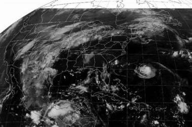
The NOAA satellite picture taken at 5 A.M. EST on Saturday, Aug. 13, 2005 showed a good deal of cloudiness streaming into the Plains from the Rockies and Southwest. Clouds were also seen pushing into northern New England along a frontal boundary. The West coast was mainly free of clouds. While the Southeast was also devoid of cloudiness, Tropical Storm Irene was visible well off the coast of the Carolinas. (AP Photo/NOAA)

📎 ahs
Đăng nhập để trả lời
0
Reuters - Sat Aug 13, 7:08 AM ET
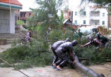
Chinese soldiers and residents remove a tree toppled by tropical storm Sanvu in Xiamen, east China's Fujian province, August 13, 2005. Extreme weather hit the country over the weekend, state media reported. A unusually humid spell continues in the north, heat waves hit the south and a typhoon tore through southeastern provinces. Sanvu is the 10th severe tropical storm to hit China this year. CHINA OUT REUTERS/China Newsphoto

📎 acc
Đăng nhập để trả lời
0
AFP/File - Sun Aug 7, 7:09 PM ET
The wreckage of a small aircraft leans against a tree after Hurricane Emily hit the area in Playa del Carmen, Mexico. 2005 is set to be one of the worst years on record for hurricanes, scientists say, amid spectacular new evidence about the power of these storms and fears that global warming is intensifying them.(AFP/File/Omar Torres)

📎 aam
Đăng nhập để trả lời
0
AFP/File - Sat Sep 10, 8:42 AM ET
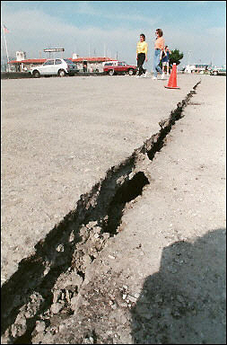
San Francisco residents walk past a cracked road after an earthquake measuring 6.9 on the Richter scale struck California in 1989. The US Geological Survey (USGS) told AFP that an earthquake of magnitude 6.7 or more in the San Francisco region would be more destructive that Hurricane Katrina.(AFP/File/Jonathan Nourok)

📎 aearthq
Đăng nhập để trả lời
0

Ilametepec Volcano, El Salvador


02-October-2005

>>>>>>>>>>>>


Country: El Salvador
Subregion Name: El Salvador
Volcano Number: 1403-02=
Volcano Type: Stratovolcano
Volcano Status: Historical
Last Known Eruption: 1920
Summit Elevation: 2381 m 7,812 feet
Latitude: 13.853°N 13°51'12"N
Longitude: 89.630°W 89°37'48"W

Santa Ana, El Salvador's highest volcano, is a massive, 2381-m-high andesitic-to-basaltic stratovolcano that rises immediately west of Coatepeque caldera. Collapse of the volcano during the late Pleistocene produced a voluminous debris avalanche that swept into the Pacific Ocean, forming the Acajutla Peninsula. Reconstruction of the volcano subsequently filled most of the collapse scarp. The broad summit of the volcano is cut by several crescentic craters, and a series of parasitic vents and cones have formed along a 20-km-long fissure system that extends from near the town of Chalchuapa NNW of the volcano to the San Marcelino and Cerro la Olla cinder cones on the SE flank. Historical activity, largely consisting of small-to-moderate explosive eruptions from both summit and flank vents, has been documented since the 16th century. The San Marcelino cinder cone on the SE flank produced a lava flow in 1722 that traveled 13 km to the east.


http://www.volcano.si.edu/world/volcano.cfm?vnum=1403-02=
Đăng nhập để trả lời
0
Tropical Storm Stan Hits Southern Mexico

By JORGE BARRERA, Associated Press Writer
Sun Oct 2, 4:11 PM ET

LA PAZ, Mexico - Hurricane Otis weakened to a tropical storm Sunday and headed north toward an unpopulated stretch of the Baja California Peninsula, while a tropical depression strengthened to a tropical storm just before hitting land in southern Mexico.

Tropical Storm Stan formed before dawn Sunday and then plowed into land about 40 miles southwest of Tulum, on the Yucatan Peninsula. It carried maximum sustained winds of 45 mph, the National Hurricane Center in Miami said.

The storm was expected to dump up to 15 inches of rain in some areas of the Yucatan Peninsula and Belize before weakening to a tropical depression. No major damages or injuries were immediately reported, and the storm was expected to move mostly south of the popular resort of Cancun.

Along the Pacific coast, the Mexican government issued a tropical storm warning for the southern tip of the Baja California peninsula as Otis continued to sideswipe the narrow stretch of land. No injuries have been reported.

The slow-moving storm was inching along the coastline at 3 mph and was expected to hit a deserted stretch of coastline late Sunday or early Monday. It carried maximum sustained winds of 70 mph and was expected to weaken over the next 24 hours, the National Hurricane Center said.

Preparing for the storm, Baja California state officials had asked soldiers to help evacuate the islands of Magdalena and Margarita, off the coast of Comondu.

Over 1,000 people evacuated by Saturday as rains from the storm's outer bands led to flooding in the poor outskirts of Cabo San Lucas, where many homes are little more than wooden shacks. Officials went door-to-door as part of a voluntary evacuation plan.

The resort's hotels in Cabo San Lucas escaped major flooding.

Otis was the 15th Pacific storm of the season. Unlike powerful Atlantic storms such as Hurricanes Katrina and Rita, Pacific hurricanes tend to do less damage because they make landfall less frequently.

Like their counterparts in the Atlantic, Pacific storms are given names that correspond to the alphabet.

http://news.yahoo.com/s/ap/20051002/ap_on_re_la_am_ca/tropical_weather
Đăng nhập để trả lời
0
Why did you send every the news,we didn't need it.We can read it on YAHOO or Google.


Why don't you send someone books?

That i'm thinking
Lữ Hiệp Vô Danh. ((((Danh Hiệu:Kẻ Vô Tình))))
Đăng nhập để trả lời
0

Guangdong is seeing its worst flooding for at least 90 years


Saturday, 25 June, 2005, 07:12 GMT 08:12 UK

China flood death toll 'over 500'

Summer floods in China have killed 567 people and forced over two million from their homes, the government has said.
Torrential rains in much of the country have left areas of southern China submerged beneath muddy waters in the deadliest early floods for a decade.

Heavy rains have come sooner than usual, leaving the city of Wuzhou, and the provinces of Guangxi and Guangdong seriously affected.

President Hu Jintao has ordered officials to increase emergency relief.

"Faced with a serious fight against the floods... we must quickly step up efforts at organising construction and inspections of major dykes, reservoirs and reserve flood areas," he said at a flood prevention meeting, quoted by People's Daily newspaper.

Officials have warned of the spread of cholera and other intestinal diseases.

The Chinese Health Ministry said, quoted by China News Service, that nearly 3,400 cases of cholera, dysentery and typhoid fever had been recorded in the first six months of the year, and that the figure was still rising.

The worst flooding in recent years was in 1998, when 4,150 people died.

Rivers have burst their banks and mudslides have contributed to the death toll in the south, where 124 people died in the past week, Chinese state media said.

Central drought

Chinese officials expressed concern that the floods have yet to peak.

Some 2.45 million people have been evacuated from their homes, officials said.


In pictures: Floods take toll

In Wuzhou, a city of 300,000 people, residents were forced to construct makeshift boats and rafts as flood water approached the upper floors of houses.

Meanwhile water levels reached their highest in at least 90 years in the Pearl River, which flows past the regional business centre Guangdong.

Much of China is hit by floods every year, often spreading quickly because of deforested hillsides that trigger landslides and do not prevent flood waters from building up.

The floods, which have come early in the annual wet season, have caused an estimated 22.9bn yuan ($2.77bn) worth of damage, reports say.

Hong Kong was hit by heavy rains on Friday, causing traffic delays.

Services on the main rail line from Hong Kong to China were suspended after a landslide.

The situation in the south contrasted with soaring temperatures in central and northern regions.

The central province of Anhui is enduring a record drought, while a heat wave has persisted in the Chinese capital, Beijing.

Are you in China or Hong Kong, and have you been affected by the floods? Do you know people who have? Send us your comments using the form below:

..................
http://news.bbc.co.uk/2/hi/asia-pacific/4617891.stm
Đăng nhập để trả lời
0
Friday, 24 June, 2005, 09:43 GMT 10:43 UK

In pictures: Floods in southern China

http://news.bbc.co.uk/2/hi/in_pictures/4618411.stm


Heavy rains in southern China have caused flooding and widespread damage.


In some places, the only way about is by boat.


.....
Đăng nhập để trả lời
0
<Bài viết đã được chỉnh sửa lúc 2005-06-27 11:54:47HongYen>
Friday, 24 June, 2005, 09:43 GMT 10:43 UK

In pictures: Floods in southern China

http://news.bbc.co.uk/2/hi/in_pictures/4618411.stm


But landslides are a more serious problem, seriously affecting services on this train line


Several vehicles were swept away in the flooding


Amid stories of bravery and survival, the death toll steadily mounted
Đăng nhập để trả lời
0
Japan: Volcanic Eruption Made Vapor Column

Vapor billows from grayish mud that is rising up from the bottom of the ocean near where a 1 kilometer- (3,300-foot) high column of water vapor shot up in the Pacific Ocean, on Sunday July 3, 2005. Japanese coast guard officials said Sunday after an aerial survey that they believe an underwater eruption has caused a 1 kilometer- (3,300-foot) high column of water vapor to shoot up from the Pacific Ocean near Iwo Jima. (AP Photo/Kyodo News)


http://news.yahoo.com/photo/050703/481/tok80107030940;_ylt=AvtSt9f1Nz3yXFWT01KZsUtxieAA;_ylu=X3oDMTA3bGk2OHYzBHNlYwN0bXA-

📎 Vocalno
Đăng nhập để trả lời
0
«« « 1 2 3 4 5 » »»